Geolocate

Ciputri topographic map

Click on the map to display elevation.

About this map
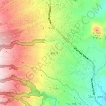
Name: Ciputri topographic map, elevation, terrain.

Location: Ciputri, Cianjur, West Java, Indonesia (-6.78884 107.02807 -6.74884 107.06807)

Average elevation: 1,119 m

Minimum elevation: 862 m

Maximum elevation: 1,388 m

Other topographic maps

Click on a map to view its topography, its elevation and its terrain.

Sindangbarang

Indonesia > West Java > Cianjur

Average elevation: 148 m

Wangunjaya

Indonesia > West Java > Cianjur

Average elevation: 17 m

Kertamukti

Indonesia > West Java > Cianjur

Average elevation: 25 m

Alun Alun Suryakancana

Indonesia > West Java > Cianjur

Average elevation: 2,568 m

Gear up for your next adventure:

🔋Lithium AA Batteries - Long-lasting power that performs well in cold mountain weather
🧴Tick Removal Tools - Small, essential health tool for UK woodland and moorland
🔋Power Banks - Portable chargers for long outdoor trips
🥼Base Layers - Thermal base layers for temperature regulation
🧢Waterproof Hiking Hats - Keep the rain off your face while studying topographic maps

As an Amazon Associate, this site earns from qualifying purchases at no extra cost to you.