
Puyallup topographic map
Click on the map to display elevation.
Puyallup
Downtown Puyallup and nearby neighborhoods lie within the hazard zone for lahars that could be produced in a moderate or large eruption of nearby Mount Rainier. The city's position on the Puyallup River is downstream of the western flank of Mount Rainier, which has the highest potential for producing far-traveled lahars due to the abundance of weakened clay-rich rock at high altitudes. The entire Puyallup Valley is built on deposits of the 5,600-year-old Osceola Mudflow, which deposited as much as 98 feet (30 m) of material and was similar to largest lahars Mount Rainier could produce. A 2009 study by the United States Geological Survey (USGS) determined that Puyallup has the highest number of dependent-population facilities, public venues, and overall community assets within lahar hazard zones. The Washington State Department of Natural Resources estimates that the Puyallup Valley could experience $6–12 billion in damage from a major lahar.
About this map
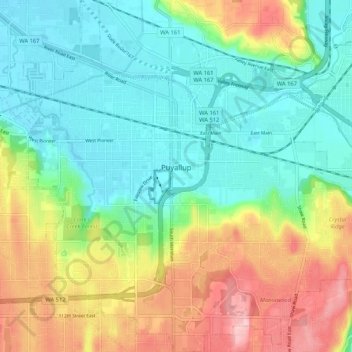
Name: Puyallup topographic map, elevation, terrain.
Location: Puyallup, Pierce County, Washington, United States (47.14731 -122.33789 47.21849 -122.23481)
Average elevation: 67 m
Minimum elevation: 4 m
Maximum elevation: 185 m
Other topographic maps
Click on a map to view its topography, its elevation and its terrain.
Mount Rainier
United States > Washington > Pierce County
Mount Rainier (/reɪˈnɪər/), indigenously known as Tahoma, Tacoma, Tacobet, or təqʷubəʔ, is a large active stratovolcano in the Cascade Range of the Pacific Northwest, located in Mount Rainier National Park about 59 miles (95 km) south-southeast of Seattle. With a summit elevation of 14,411 ft (4,392…
Average elevation: 3,911 m
Fort Lewis
United States > Washington > Pierce County
Helicopters based at the airfield assisted with medical evacuations at Mount Rainier National Park on numerous occasions in the 1970s. Army helicopters were also used to insert search-and-rescue [SAR] teams into inaccessible areas on the east, north, and west sides of the mountain, lowering rangers to the…
Average elevation: 91 m
Mount Rainier
United States > Washington > Pierce County
Mount Rainier (/reɪˈnɪər/ ray-NEER), also known as Tahoma, is a large active stratovolcano in the Cascade Range of the Pacific Northwest in the United States. The mountain is located in Mount Rainier National Park about 59 miles (95 km) south-southeast of Seattle. With a summit elevation of 14,399.6 ft…
Average elevation: 3,911 m
Gig Harbor
United States > Washington > Pierce County > Gig Harbor > Gig Harbor
Average elevation: 49 m
Mount Rainier
United States > Washington > Pierce County
Mount Rainier (/reɪˈnɪər/ ray-NEER), also known as Tahoma, is a large active stratovolcano in the Cascade Range of the Pacific Northwest in the United States. The mountain is located in Mount Rainier National Park about 59 miles (95 km) south-southeast of Seattle. With an officially recognized summit…
Average elevation: 3,911 m
Mount Rainier
United States > Washington > Pierce County
Mount Rainier (/reɪˈnɪər/ ray-NEER), also known as Tahoma, is a large active stratovolcano in the Cascade Range of the Pacific Northwest in the United States. The mountain is located in Mount Rainier National Park about 59 miles (95 km) south-southeast of Seattle. With a summit elevation of 14,411 ft…
Average elevation: 3,911 m
Mount Rainier
United States > Washington > Pierce County
Mount Rainier (/reɪˈnɪər/ ray-NEER), also known as Tahoma, is a large active stratovolcano in the Cascade Range of the Pacific Northwest in the United States. The mountain is located in Mount Rainier National Park about 59 miles (95 km) south-southeast of Seattle. With an officially recognized summit…
Average elevation: 3,911 m