Asheville topographic map
Click on the map to display elevation.
Asheville
Asheville features a climate that borders between a humid subtropical climate (Köppen Cfa/Trewartha Do) and an oceanic climate (Koppen Cfb) with noticeably cooler temperatures than the rest of the Piedmont region of the Southeast due to the higher elevation; it is part of USDA Hardiness zone 7a. The area's summers in particular, though warm, are not as hot as summers in cities farther east in the state, as the July daily average temperature is 73.8 °F (23.2 °C) and there is an average of only 9.4 afternoons with 90 °F (32.2 °C)+ highs annually; The last time a calendar year passed without a single 90 °F (32.2 °C) reading was as recent as 2009. Moreover, warm mornings where the low remains at or above 70 °F or 21.1 °C are much less common than 90 °F or 32.2 °C afternoons. Winters are cool, with a January daily average of 37.1 °F (2.8 °C) and highs remaining at or below freezing on 5.5 afternoons.
About this map
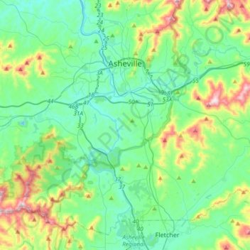
Name: Asheville topographic map, elevation, terrain.
Location: Asheville, Buncombe County, North Carolina, United States (35.41646 -82.67036 35.65608 -82.46047)
Average elevation: 727 m
Minimum elevation: 578 m
Maximum elevation: 1,209 m
Other topographic maps
Click on a map to view its topography, its elevation and its terrain.
Arden
United States > North Carolina > Buncombe County > Asheville > Royal Pines
Average elevation: 693 m
Haw Creek Park
United States > North Carolina > Buncombe County > Asheville > Dogwood Grove
Average elevation: 666 m


Falconhurst-West Asheville Preserve
United States > North Carolina > Buncombe County > Asheville
Average elevation: 647 m

Biltmore Village
United States > North Carolina > Buncombe County > Asheville
Average elevation: 642 m
Royal Pines
United States > North Carolina > Buncombe County > Asheville
Royal Pines is located in southern Buncombe County at 35°28′39″N 82°30′35″W / 35.47750°N 82.50972°W / 35.47750; -82.50972 (35.477386, -82.509833). It is bordered to the west by U.S. Route 25A and the city limits of Asheville, and to the northeast by Mills Gap Road. Brown Mountain, with an…
Average elevation: 700 m