
Eisentratten topographic map
Interactive map
Click on the map to display elevation.
About this map
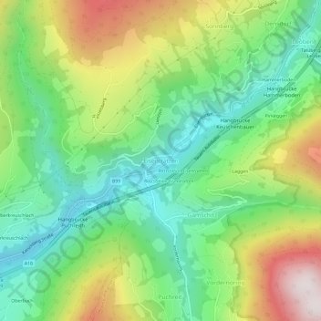
Name: Eisentratten topographic map, elevation, terrain.
Average elevation: 1,094 m
Minimum elevation: 773 m
Maximum elevation: 1,641 m
Other topographic maps
Click on a map to view its topography, its elevation and its terrain.
Innerkrems
Autriche > Carinthie > Bezirk Spittal an der Drau > Krems in Kärnten
Innerkrems, Krems in Kärnten, Bezirk Spittal an der Drau, Carinthie, Autriche
Average elevation: 1,811 m