
Otham topographic map
Click on the map to display elevation.
About this map
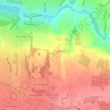
Name: Otham topographic map, elevation, terrain.
Location: Otham, Maidstone, Kent, England, United Kingdom (51.24034 0.55689 51.26433 0.58850)
Average elevation: 76 m
Minimum elevation: 20 m
Maximum elevation: 112 m
Kent trails, hiking, mountain biking, running and outdoor activities
Other topographic maps
Click on a map to view its topography, its elevation and its terrain.
The Hernitage and High Noon Farm
United Kingdom > England > Kent > Maidstone > Detling
Average elevation: 145 m