
Melville topographic map
Interactive map
Click on the map to display elevation.
Melville
Long Island's highest point is Jayne's Hill in the neighboring hamlet of West Hills, with an elevation of 387 feet (118 m) to 400.9 feet (122.2 m) above sea level.
About this map
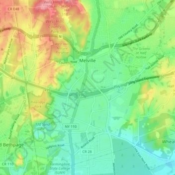
Name: Melville topographic map, elevation, terrain.
Average elevation: 53 m
Minimum elevation: 18 m
Maximum elevation: 113 m
Other topographic maps
Click on a map to view its topography, its elevation and its terrain.
Village of Lloyd Harbor
United States > New York > Suffolk County > Town of Huntington
Average elevation: 14 m
Huntington Station
United States > New York > Suffolk County > Town of Huntington
Average elevation: 60 m
Village of Northport
United States > New York > Suffolk County > Town of Huntington
Average elevation: 27 m