
Thank you for supporting this site ❤️
Make a donation
Make a donation
Gear up for your next adventure:
As an Amazon Associate, this site earns from qualifying purchases at no extra cost to you.
Dong-myeon topographic map
Click on the map to display elevation.
Thank you for supporting this site ❤️
Make a donation
Make a donation
Gear up for your next adventure:
As an Amazon Associate, this site earns from qualifying purchases at no extra cost to you.
About this map
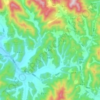
Name: Dong-myeon topographic map, elevation, terrain.
Location: Dong-myeon, Hwasun-gun, South Jeolla, 58132, South Korea (35.00507 127.00585 35.08507 127.08585)
Average elevation: 222 m
Minimum elevation: 57 m
Maximum elevation: 628 m
Thank you for supporting this site ❤️
Make a donation
Make a donation
Gear up for your next adventure:
As an Amazon Associate, this site earns from qualifying purchases at no extra cost to you.