Geolocate

Jampang topographic map

Click on the map to display elevation.

About this map

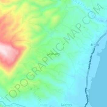
Name: Jampang topographic map, elevation, terrain.

Location: Jampang, Argao, Cebu, Central Visayas, 6021, Philippines (9.89175 123.57285 9.93175 123.61285)

Average elevation: 118 m

Minimum elevation: -3 m

Maximum elevation: 432 m

Gear up for your next adventure:

Lightweight Tents - Compact tents for backpacking and trekking
🧰First Aid Kits - Essential safety kits for outdoor activities
🎒Hiking Daypacks (20L) - Compact backpacks for day trips and technical mountain ascents
📦Dry Bags - Waterproof bags to protect gear from rain
Insulated Travel Mugs - Keep drinks hot while surveying the landscape from a summit

As an Amazon Associate, this site earns from qualifying purchases at no extra cost to you.