
Gyumri topographic map
Interactive map
Click on the map to display elevation.
Gyumri
Gyumri is 126 kilometres (78 miles) north of the capital Yerevan at the central part of the Shirak plateau. It has an approximate height of 1,550 metres (5,090 feet) above sea level, the high altitude line being 1,500 metres (4,900 feet). The Akhurian River passes through the western suburbs. The Shirak plateau is surrounded with the Pambak Mountains from the east and Aragats volcanic range from the south. The city of Gyumri is 196 kilometres (122 miles) away from the Black Sea. The surrounding lands near the city are rich in tufa, basalt and clay.
About this map
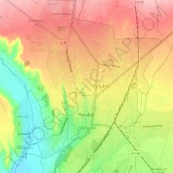
Name: Gyumri topographic map, elevation, terrain.
Location: Gyumri, Border Gyumri-Akhuryan, Shirak Province, Armenia (40.76031 43.80744 40.83304 43.88349)
Average elevation: 1,547 m
Minimum elevation: 1,468 m
Maximum elevation: 1,616 m
Other topographic maps
Click on a map to view its topography, its elevation and its terrain.
Aragats
Mount Aragats has a topographic prominence of 2,143 meters, more than some higher mountains, such as Dykh-Tau (5,205 m high) in the Russian part of Great Caucasus Range.
Average elevation: 3,645 m
Gyumri
Armenia > Shirak Province > Gyumri
Gyumri is 126 kilometres (78 miles) north of the capital Yerevan at the central part of the Shirak plateau. It has an approximate height of 1,550 metres (5,090 feet) above sea level, the high altitude line being 1,500 metres (4,900 feet). The Akhurian River passes through the western suburbs. The Shirak…
Average elevation: 1,535 m
Gyumri
Gyumri is 126 kilometres (78 miles) north of the capital Yerevan at the central part of the Shirak plateau. It has an approximate height of 1,550 metres (5,090 feet) above sea level, the high altitude line being 1,500 metres (4,900 feet). The Akhurian River passes through the western suburbs. The Shirak…
Average elevation: 1,535 m