Geolocate

Springbrook topographic map

Click on the map to display elevation.

About this map

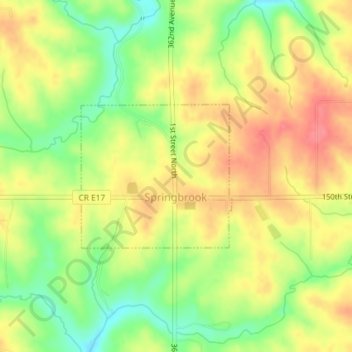
Name: Springbrook topographic map, elevation, terrain.

Location: Springbrook, Jackson County, Iowa, United States (42.16006 -90.48685 42.17109 -90.47122)

Average elevation: 244 m

Minimum elevation: 206 m

Maximum elevation: 275 m

Other topographic maps

Click on a map to view its topography, its elevation and its terrain.

Fulton

United States > Iowa > Jackson County

Average elevation: 231 m

Ozark

United States > Iowa > Jackson County

Average elevation: 266 m

Ozark

United States > Iowa > Jackson County

Average elevation: 266 m

Ozark

United States > Iowa > Jackson County

Average elevation: 266 m

Gear up for your next adventure:

🔋Solar Chargers - Eco-friendly charging solutions for outdoor use
📦Dry Bags - Waterproof bags to protect gear from rain
🔋Power Banks - Portable chargers for long outdoor trips
🧣Neck Gaiters - Protects against wind and sun on exposed ridges and peaks
🧤Hiking Gloves - Warm and durable gloves for cold-weather walks

As an Amazon Associate, this site earns from qualifying purchases at no extra cost to you.