
Quinchães topographic map
Interactive map
Click on the map to display elevation.
About this map
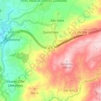
Name: Quinchães topographic map, elevation, terrain.
Location: Quinchães, Fafe, Braga, Portugal (41.41071 -8.16751 41.45564 -8.10625)
Average elevation: 480 m
Minimum elevation: 293 m
Maximum elevation: 696 m
Other topographic maps
Click on a map to view its topography, its elevation and its terrain.
Santa Comba
Portugal > Braga > Fafe > Fornelos
Santa Comba, Fornelos, Fafe, Braga, 4820-412, Portugal
Average elevation: 338 m