Geolocate

Rocinha topographic map

Click on the map to display elevation.

About this map

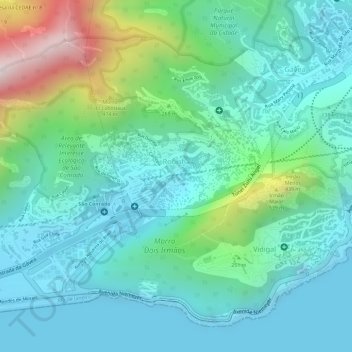
Name: Rocinha topographic map, elevation, terrain.

Location: Rocinha, Rio de Janeiro, Southeast Region, Brazil (-22.99586 -43.25711 -22.98344 -43.23978)

Average elevation: 161 m

Minimum elevation: -1 m

Maximum elevation: 660 m

Other topographic maps

Click on a map to view its topography, its elevation and its terrain.

Sugarloaf

Brazil > Rio de Janeiro > Rio de Janeiro

Average elevation: 17 m

Gear up for your next adventure:

🗺️Topographic Maps - Detailed maps showing elevation and terrain features
🥾Hiking Boot Waterproofing Wax - Maintain the lifespan of your leather trekking boots
🌦️Portable Weather Meters - Handheld tools for monitoring weather conditions
🥤Hiking Water Bottles - Reusable bottles for hydration on the trail
🔋Solar Chargers - Eco-friendly charging solutions for outdoor use

As an Amazon Associate, this site earns from qualifying purchases at no extra cost to you.