
Make a donation
Gear up for your next adventure:
As an Amazon Associate, this site earns from qualifying purchases at no extra cost to you.
Grose Valley topographic map
Click on the map to display elevation.
Make a donation
Gear up for your next adventure:
As an Amazon Associate, this site earns from qualifying purchases at no extra cost to you.
Grose Valley
The bulk of the vegetation in the wilderness is dry open forest and woodland, dominated by Eucalyptus sieberi and E. piperita above 800 metres (2,600 ft) altitude with Eucalyptus oblonga, E. globoidea, E. agglomerata and Angophora costata becoming dominant at lower altitudes. Plateau areas have thinner or waterlogged soils and generally support heath or low open woodland communities. Within the sheltered and well watered canyon environments closed forests commonly occur, with typical species being coachwood, sassafras and possumwood. On the isolated basalt caps the fertile soils support taller eucalypt forests of E. viminalis, E. blaxlandii and E. fastigata. A small area of alluvial sediments deposited in the upper Grose Valley during the Quaternary supports a tall moist open forest dominated by E. deanei, E. oreades, E. notabilis and E. cypelocarpa. The Blue Gum Forest is included in this forest type.
Make a donation
Gear up for your next adventure:
As an Amazon Associate, this site earns from qualifying purchases at no extra cost to you.
About this map
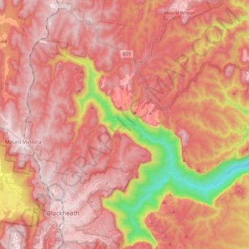
Name: Grose Valley topographic map, elevation, terrain.
Average elevation: 833 m
Minimum elevation: 265 m
Maximum elevation: 1,107 m
Make a donation
Gear up for your next adventure:
As an Amazon Associate, this site earns from qualifying purchases at no extra cost to you.
Other topographic maps
Click on a map to view its topography, its elevation and its terrain.