
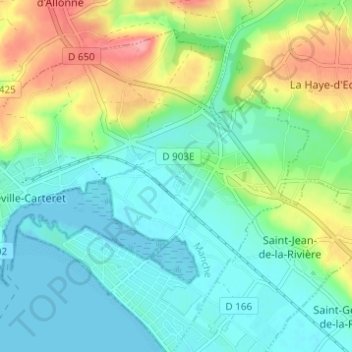
Le Dessous du Bourg topographic map
Interactive map
Click on the map to display elevation.
About this map
Name: Le Dessous du Bourg topographic map, elevation, terrain.
Average elevation: 29 m
Minimum elevation: -1 m
Maximum elevation: 97 m
Other topographic maps
Click on a map to view its topography, its elevation and its terrain.
Le Pont Rose
France > Normandie > Manche > Barneville-Carteret
Le Pont Rose, Barneville-Carteret, Cherbourg, Manche, Normandie, France métropolitaine, 50270, France
Average elevation: 37 m
Les Moulins
France > Normandie > Manche > Barneville-Carteret
Les Moulins, Barneville-Carteret, Cherbourg, Manche, Normandie, France métropolitaine, 50270, France
Average elevation: 32 m
Hameau Boudet
France > Normandie > Manche > Barneville-Carteret
Hameau Boudet, Barneville-Carteret, Cherbourg, Manche, Normandie, France métropolitaine, 50270, France
Average elevation: 33 m
Le Hameau de Bas
France > Normandie > Manche > Barneville-Carteret > Le Hameau de Bas
Le Hameau de Bas, Barneville-Carteret, Cherbourg, Manche, Normandie, France métropolitaine, 50270, France
Average elevation: 20 m
Le Petit Hameau
France > Normandie > Manche > Barneville-Carteret
Le Petit Hameau, Barneville-Carteret, Cherbourg, Manche, Normandie, France métropolitaine, 50270, France
Average elevation: 21 m
Le Valnotte
France > Normandie > Manche > Barneville-Carteret
Le Valnotte, Barneville-Carteret, Cherbourg, Manche, Normandie, France métropolitaine, 50270, France
Average elevation: 35 m
Quinetot
France > Normandie > Manche > Barneville-Carteret
Quinetot, Barneville-Carteret, Cherbourg, Manche, Normandie, France métropolitaine, 50270, France
Average elevation: 38 m