Geolocate

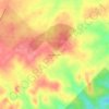
Fair Oaks Ranch topographic map

Click on the map to display elevation.

About this map
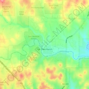
Name: Fair Oaks Ranch topographic map, elevation, terrain.

Location: Fair Oaks Ranch, Comal County, Texas, United States (29.71375 -98.67273 29.78513 -98.60687)

Average elevation: 409 m

Minimum elevation: 369 m

Maximum elevation: 463 m

Other topographic maps

Click on a map to view its topography, its elevation and its terrain.
Bulverde

United States > Texas > Comal County

Average elevation: 364 m

villas pool

United States > Texas > Comal County > Bulverde

Average elevation: 378 m

Spring Branch

United States > Texas > Comal County

Average elevation: 348 m

Fischer

United States > Texas > Comal County

Average elevation: 363 m

Royal Forest

United States > Texas > Comal County > Royal Forest

Average elevation: 306 m

Glenbrook

United States > Texas > Comal County > New Braunfels

Average elevation: 201 m

Freiheit

United States > Texas > Comal County > New Braunfels

Average elevation: 204 m

Smithson Valley

United States > Texas > Comal County

Average elevation: 388 m

Woodrow

United States > Texas > Comal County > New Braunfels

Average elevation: 219 m

Cranes Mill

United States > Texas > Comal County

Average elevation: 361 m

Oak Run

United States > Texas > Comal County > New Braunfels

Average elevation: 254 m

Cranes Mill

United States > Texas > Comal County

Average elevation: 308 m

New Braunfels

United States > Texas > Comal County

Average elevation: 228 m

Gear up for your next adventure:

🥫Expedition Meals - Lightweight, high-calorie nutrition for long-distance hikers
🎒Backpack Rain Covers - Universal waterproof covers to protect your gear from downpours
📦Compression Sacks - Reduce backpack volume efficiently
🔦Keychain LED Torches - Emergency backup light for finding gear in your pack
🥾Women's Waterproof Hiking Boots - High-performance trekking boots designed for all-weather comfort

As an Amazon Associate, this site earns from qualifying purchases at no extra cost to you.