
Make a donation
Gear up for your next adventure:
As an Amazon Associate, this site earns from qualifying purchases at no extra cost to you.
Farmington River topographic map
Click on the map to display elevation.
Make a donation
Gear up for your next adventure:
As an Amazon Associate, this site earns from qualifying purchases at no extra cost to you.
About this map
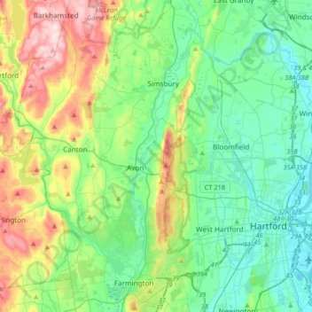
Name: Farmington River topographic map, elevation, terrain.
Average elevation: 102 m
Minimum elevation: 1 m
Maximum elevation: 367 m
Make a donation
Gear up for your next adventure:
As an Amazon Associate, this site earns from qualifying purchases at no extra cost to you.
Other topographic maps
Click on a map to view its topography, its elevation and its terrain.
Newington Junction
United States > Connecticut > Hartford County > Newington > Newington Junction
Average elevation: 33 m
East Glastonbury
United States > Connecticut > Hartford County > Glastonbury > East Glastonbury
Average elevation: 131 m
Bull Run Corner
United States > Connecticut > Hartford County > Windsor Locks > Bull Run Corner
Average elevation: 45 m
Manchester Green
United States > Connecticut > Hartford County > Manchester > Manchester Green
Average elevation: 101 m
Make a donation
Gear up for your next adventure:
As an Amazon Associate, this site earns from qualifying purchases at no extra cost to you.