
Kosjerić (town) topographic map
Interactive map
Click on the map to display elevation.
Kosjerić (town)
Kosjeríć (Serbian Cyrillic: Косјерић, pronounced [kɔsjɛ̌rit͡ɕ]) is a town and municipality located in the Zlatibor District of western Serbia. The municipality has a population of 12,090 inhabitants, but the town itself has 3,992. The municipality's area is 359 square kilometres (139 sq mi), with 26 villages mostly placed in the river valleys, though there are also some settlements in the mountains at altitudes of more than 1,000 metres (3,300 feet).
About this map
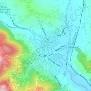
Name: Kosjerić (town) topographic map, elevation, terrain.
Average elevation: 465 m
Minimum elevation: 398 m
Maximum elevation: 695 m
Other topographic maps
Click on a map to view its topography, its elevation and its terrain.
Radanovci
Serbia > Central Serbia > Zlatibor Administrative District > Kosjeric Municipality
Average elevation: 691 m