
Maidford topographic map
Click on the map to display elevation.
About this map
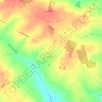
Name: Maidford topographic map, elevation, terrain.
Location: Maidford, West Northamptonshire, England, United Kingdom (52.15246 -1.12860 52.18571 -1.09144)
Average elevation: 157 m
Minimum elevation: 121 m
Maximum elevation: 181 m
West Northamptonshire trails, hiking, mountain biking, running and outdoor activities
Other topographic maps
Click on a map to view its topography, its elevation and its terrain.
Lower Thorpe
United Kingdom > England > West Northamptonshire > Thorpe Mandeville
Average elevation: 154 m
Ravensthorpe Reservoir
United Kingdom > England > West Northamptonshire > Coton
Average elevation: 131 m