
Slivník topographic map
Interactive map
Click on the map to display elevation.
About this map
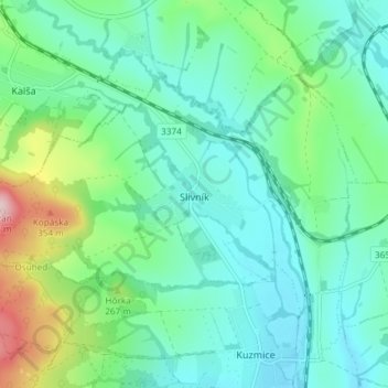
Name: Slivník topographic map, elevation, terrain.
Average elevation: 209 m
Minimum elevation: 145 m
Maximum elevation: 422 m
Die Gemeinde befindet sich im südwestlichen Teil des Ostslowakischen Tieflands unterhalb des Gebirges Slanské vrchy an den Flüsschen Terebľa und Roňava, nahe der slowakisch-ungarischen Staatsgrenze. Das Ortszentrum liegt auf einer Höhe von 172 m n.m. und ist 18 Kilometer von Trebišov entfernt.
Other topographic maps
Click on a map to view its topography, its elevation and its terrain.
Leles
Slowakei > Kaschauer Landschaftsverband > Bezirk Trebischau
Leles, Bezirk Trebischau, Kaschauer Landschaftsverband, Ostslowakei, 076 84, Slowakei
Average elevation: 101 m