Geolocate

Odlabari topographic map

Click on the map to display elevation.

About this map

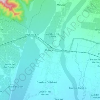
Name: Odlabari topographic map, elevation, terrain.

Location: Odlabari, Mal, Jalpaiguri District, West Bengal, 735222, India (26.82469 88.58365 26.90469 88.66365)

Average elevation: 168 m

Minimum elevation: 127 m

Maximum elevation: 497 m

Gear up for your next adventure:

🚶Walking Pedometers - Simple distance tracking for casual trail walkers
🌦️Portable Weather Meters - Handheld tools for monitoring weather conditions
Lightweight Tents - Compact tents for backpacking and trekking
Camping Shelters - Emergency and lightweight shelters for outdoor use
🧴Tick Removal Tools - Small, essential health tool for UK woodland and moorland

As an Amazon Associate, this site earns from qualifying purchases at no extra cost to you.