浜寺船尾町西はまなす広場 topographic map
Interactive map
Click on the map to display elevation.
About this map
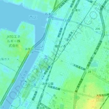
Name: 浜寺船尾町西はまなす広場 topographic map, elevation, terrain.
Average elevation: 6 m
Minimum elevation: -1 m
Maximum elevation: 21 m

Click on the map to display elevation.
Name: 浜寺船尾町西はまなす広場 topographic map, elevation, terrain.
Average elevation: 6 m
Minimum elevation: -1 m
Maximum elevation: 21 m