Ragged Island topographic map
Interactive map
Click on the map to display elevation.
About this map
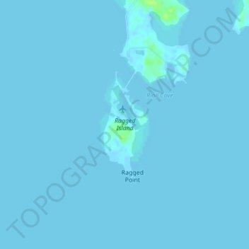
Name: Ragged Island topographic map, elevation, terrain.
Location: Ragged Island, Dorchester County, Maryland, United States (38.53169 -76.27868 38.54328 -76.27231)
Average elevation: 0 m
Minimum elevation: -2 m
Maximum elevation: 11 m
Other topographic maps
Click on a map to view its topography, its elevation and its terrain.
Green Cove
United States > Maryland > Dorchester County
Green Cove, Dorchester County, Maryland, United States
Average elevation: 1 m
Riverton
United States > Maryland > Dorchester County
Riverton, Dorchester County, Maryland, United States
Average elevation: 2 m
Ripling Waters
United States > Maryland > Dorchester County > Ripling Waters
Ripling Waters, Dorchester County, Maryland, 21677, United States
Average elevation: 1 m
Cambridge
United States > Maryland > Dorchester County
Cambridge, Dorchester County, Maryland, 21613, United States
Average elevation: 3 m
Ellwood
United States > Maryland > Dorchester County
Ellwood, Dorchester County, Maryland, 21643, United States
Average elevation: 11 m