
Thank you for supporting this site ❤️
Make a donation
Make a donation
Gear up for your next adventure:
As an Amazon Associate, this site earns from qualifying purchases at no extra cost to you.
Aserrí topographic map
Click on the map to display elevation.
Thank you for supporting this site ❤️
Make a donation
Make a donation
Gear up for your next adventure:
As an Amazon Associate, this site earns from qualifying purchases at no extra cost to you.
About this map
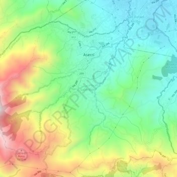
Name: Aserrí topographic map, elevation, terrain.
Location: Aserrí, Cantón Aserrí, San Jose Province, 10601, Costa Rica (9.83160 -84.13664 9.87575 -84.07897)
Average elevation: 1,499 m
Minimum elevation: 1,160 m
Maximum elevation: 2,100 m
Thank you for supporting this site ❤️
Make a donation
Make a donation
Gear up for your next adventure:
As an Amazon Associate, this site earns from qualifying purchases at no extra cost to you.