
Make a donation
Gear up for your next adventure:
As an Amazon Associate, this site earns from qualifying purchases at no extra cost to you.
Spernal topographic map
Click on the map to display elevation.
Make a donation
Gear up for your next adventure:
As an Amazon Associate, this site earns from qualifying purchases at no extra cost to you.
About this map
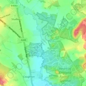
Name: Spernal topographic map, elevation, terrain.
Average elevation: 73 m
Minimum elevation: 48 m
Maximum elevation: 127 m
Warwickshire trails, hiking, mountain biking, running and outdoor activities
Make a donation
Gear up for your next adventure:
As an Amazon Associate, this site earns from qualifying purchases at no extra cost to you.
Other topographic maps
Click on a map to view its topography, its elevation and its terrain.
Compton Verney CP
United Kingdom > England > Warwickshire > Stratford-on-Avon
Average elevation: 103 m
Bidford on Avon CP
United Kingdom > England > Warwickshire > Stratford-on-Avon
Average elevation: 42 m
Make a donation
Gear up for your next adventure:
As an Amazon Associate, this site earns from qualifying purchases at no extra cost to you.
Stratford-on-Avon
United Kingdom > England > Warwickshire > Stratford-on-Avon
Average elevation: 108 m
Make a donation
Gear up for your next adventure:
As an Amazon Associate, this site earns from qualifying purchases at no extra cost to you.
Big Clowes Wood
United Kingdom > England > Warwickshire > Stratford-on-Avon > Tanworth in Arden CP
Average elevation: 152 m
Tanworth in Arden CP
United Kingdom > England > Warwickshire > Stratford-on-Avon
Average elevation: 139 m
Make a donation
Gear up for your next adventure:
As an Amazon Associate, this site earns from qualifying purchases at no extra cost to you.
Stratford-upon-Avon
United Kingdom > England > Warwickshire > Stratford-on-Avon
Average elevation: 61 m
Make a donation
Gear up for your next adventure:
As an Amazon Associate, this site earns from qualifying purchases at no extra cost to you.
Bishops Itchington
United Kingdom > England > Warwickshire > Stratford-on-Avon
Average elevation: 104 m
Burton Dassett Hills Country Park
United Kingdom > England > Warwickshire > Stratford-on-Avon > Northend > Burton Dassett CP
Average elevation: 132 m
Make a donation
Gear up for your next adventure:
As an Amazon Associate, this site earns from qualifying purchases at no extra cost to you.
Stretton-on-Fosse
United Kingdom > England > Warwickshire > Stratford-on-Avon
Average elevation: 108 m
Priors Hardwick CP
United Kingdom > England > Warwickshire > Stratford-on-Avon
Average elevation: 134 m
Make a donation
Gear up for your next adventure:
As an Amazon Associate, this site earns from qualifying purchases at no extra cost to you.
Welford on Avon CP
United Kingdom > England > Warwickshire > Stratford-on-Avon
Average elevation: 44 m
Oversley Wood
United Kingdom > England > Warwickshire > Stratford-on-Avon > Alcester > Exhall
Average elevation: 64 m
Make a donation
Gear up for your next adventure:
As an Amazon Associate, this site earns from qualifying purchases at no extra cost to you.
Barcheston
United Kingdom > England > Warwickshire > Stratford-on-Avon > Willington
Average elevation: 82 m
Burton Dassett CP
United Kingdom > England > Warwickshire > Stratford-on-Avon
Average elevation: 119 m
Make a donation
Gear up for your next adventure:
As an Amazon Associate, this site earns from qualifying purchases at no extra cost to you.
Pillerton Hersey CP
United Kingdom > England > Warwickshire > Stratford-on-Avon
Average elevation: 92 m
Make a donation
Gear up for your next adventure:
As an Amazon Associate, this site earns from qualifying purchases at no extra cost to you.
Sutton under Brailes
United Kingdom > England > Warwickshire > Stratford-on-Avon
Average elevation: 132 m
River Avon
United Kingdom > England > Warwickshire > Stratford-on-Avon > Stratford-upon-Avon > Clifford Chambers
Average elevation: 43 m
Make a donation
Gear up for your next adventure:
As an Amazon Associate, this site earns from qualifying purchases at no extra cost to you.
Brailes
United Kingdom > England > Warwickshire > Stratford-on-Avon > Lower Brailes
Average elevation: 139 m
Make a donation
Gear up for your next adventure:
As an Amazon Associate, this site earns from qualifying purchases at no extra cost to you.
Ladbroke (Millennium Green)
United Kingdom > England > Warwickshire > Stratford-on-Avon > Ladbroke CP
Average elevation: 98 m
Make a donation
Gear up for your next adventure:
As an Amazon Associate, this site earns from qualifying purchases at no extra cost to you.
Make a donation
Gear up for your next adventure:
As an Amazon Associate, this site earns from qualifying purchases at no extra cost to you.
Barton-on-the-Heath
United Kingdom > England > Warwickshire > Stratford-on-Avon
Average elevation: 130 m
Make a donation
Gear up for your next adventure:
As an Amazon Associate, this site earns from qualifying purchases at no extra cost to you.
Bidford on Avon CP
United Kingdom > England > Warwickshire > Stratford-on-Avon
Average elevation: 42 m
Preston on Stour CP
United Kingdom > England > Warwickshire > Stratford-on-Avon
Average elevation: 56 m
Bishops Itchington
United Kingdom > England > Warwickshire > Stratford-on-Avon
Average elevation: 104 m
Make a donation
Gear up for your next adventure:
As an Amazon Associate, this site earns from qualifying purchases at no extra cost to you.
Burton Dassett CP
United Kingdom > England > Warwickshire > Stratford-on-Avon
Average elevation: 119 m
Stratford-upon-Avon
United Kingdom > England > Warwickshire > Stratford-on-Avon
Average elevation: 61 m
Make a donation
Gear up for your next adventure:
As an Amazon Associate, this site earns from qualifying purchases at no extra cost to you.
Stratford-upon-Avon
United Kingdom > England > Warwickshire > Stratford-on-Avon
Average elevation: 61 m
Stratford-upon-Avon
United Kingdom > England > Warwickshire > Stratford-on-Avon
Average elevation: 61 m
Stratford-upon-Avon
United Kingdom > England > Warwickshire > Stratford-on-Avon
Average elevation: 61 m