
Tracy City topographic map
Interactive map
Click on the map to display elevation.
About this map
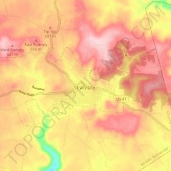
Name: Tracy City topographic map, elevation, terrain.
Average elevation: 578 m
Minimum elevation: 445 m
Maximum elevation: 649 m
Other topographic maps
Click on a map to view its topography, its elevation and its terrain.
Altamont
United States > Tennessee > Grundy County
Altamont was established in 1848 as a county seat for Grundy County, which had been created in 1844. General Adrian Northcutt, a prominent local farmer and military officer, was the prime advocate for the site's selection. The town's name comes from combining alto (meaning "altitude") and mont (meaning…
Average elevation: 565 m