
Winchester Bay topographic map
Interactive map
Click on the map to display elevation.
About this map
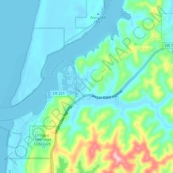
Name: Winchester Bay topographic map, elevation, terrain.
Average elevation: 44 m
Minimum elevation: -6 m
Maximum elevation: 224 m
Other topographic maps
Click on a map to view its topography, its elevation and its terrain.
Roseburg
United States > Oregon > Douglas County
Roseburg's elevation is approximately 500 feet (150 m). Its highest point is Mount Nebo, a 1,200-foot (370 m) hill to the west of Interstate 5. Through the 1980s, it was known for its band of 10-20 feral angora goats. Residents said they could predict the weather by watching where the goats were on the…
Average elevation: 239 m