
Make a donation
Gear up for your next adventure:
As an Amazon Associate, this site earns from qualifying purchases at no extra cost to you.
Tuamasaga topographic map
Click on the map to display elevation.
Make a donation
Gear up for your next adventure:
As an Amazon Associate, this site earns from qualifying purchases at no extra cost to you.
About this map
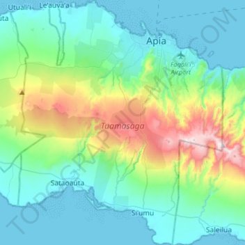
Name: Tuamasaga topographic map, elevation, terrain.
Location: Tuamasaga, Samoa (-14.04473 -171.91892 -13.79295 -171.69434)
Average elevation: 243 m
Minimum elevation: 0 m
Maximum elevation: 1,148 m
Make a donation
Gear up for your next adventure:
As an Amazon Associate, this site earns from qualifying purchases at no extra cost to you.
Other topographic maps
Click on a map to view its topography, its elevation and its terrain.
Apia
Apia is situated on a natural harbour at the mouth of the Vaisigano River. It is on a narrow coastal plain with Mount Vaea (elevation 472 metres (1,549 ft)), the burial place of writer Robert Louis Stevenson, directly to its south. Two main ridges run south on either side of the Vaisigano River, with roads on…
Average elevation: 174 m
Make a donation
Gear up for your next adventure:
As an Amazon Associate, this site earns from qualifying purchases at no extra cost to you.
Make a donation
Gear up for your next adventure:
As an Amazon Associate, this site earns from qualifying purchases at no extra cost to you.