
Reed Plantation topographic map
Interactive map
Click on the map to display elevation.
About this map
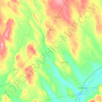
Name: Reed Plantation topographic map, elevation, terrain.
Location: Reed Plantation, Aroostook County, Maine, United States (45.62039 -68.16706 45.76598 -68.03412)
Average elevation: 141 m
Minimum elevation: 94 m
Maximum elevation: 202 m
Other topographic maps
Click on a map to view its topography, its elevation and its terrain.
Saint John River
United States > Maine > Aroostook County > Saint John Plantation
The eastern Algonquin languages had different dialects associated with each of the major river systems of New England and the Maritimes; and there was often a linguistic bifurcation between residents of the upper river and those living along the coast and tidal estuary. The Passamaquoddy hunted sea mammals…
Average elevation: 198 m