
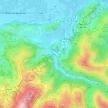
Les Angles topographic map
Interactive map
Click on the map to display elevation.
About this map
Name: Les Angles topographic map, elevation, terrain.
Average elevation: 529 m
Minimum elevation: 402 m
Maximum elevation: 796 m
Other topographic maps
Click on a map to view its topography, its elevation and its terrain.
Tarbes
France > Occitania > Hautes Pyrenees
Tarbes, Hautes Pyrenees, Occitania, Metropolitan France, 65000, France
Average elevation: 308 m
Germ
France > Occitania > Hautes Pyrenees
Germ, Bagnères-de-Bigorre, Hautes Pyrenees, Occitania, Metropolitan France, 65240, France
Average elevation: 1,677 m
Grust
France > Occitania > Hautes Pyrenees > Grust
Grust, Argelès-Gazost, Hautes Pyrenees, Occitania, Metropolitan France, 65120, France
Average elevation: 1,149 m