
Bialla topographic map
Interactive map
Click on the map to display elevation.
About this map
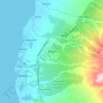
Name: Bialla topographic map, elevation, terrain.
Location: Bialla, West New Britain, Islands Region, Papua New Guinea (-5.36219 150.99066 -5.28219 151.07066)
Average elevation: 89 m
Minimum elevation: -1 m
Maximum elevation: 463 m
Other topographic maps
Click on a map to view its topography, its elevation and its terrain.
Gurisi
Papua New Guinea > West New Britain
Gurisi, West New Britain, Islands Region, Papua New Guinea
Average elevation: 12 m
Bismarck Archipelago
Papua New Guinea > West New Britain
Bismarck Archipelago, West New Britain, Islands Region, Papua New Guinea
Average elevation: 0 m
Hulem
Papua New Guinea > West New Britain
Hulem, West New Britain, Islands Region, Papua New Guinea
Average elevation: 428 m