
Make a donation
Gear up for your next adventure:
As an Amazon Associate, this site earns from qualifying purchases at no extra cost to you.
Lalgola topographic map
Click on the map to display elevation.
Make a donation
Gear up for your next adventure:
As an Amazon Associate, this site earns from qualifying purchases at no extra cost to you.
Lalgola
Lalgola is located at 24°25′N 88°15′E / 24.42°N 88.25°E / 24.42; 88.25. It is located near the Padma River, which is the principal distributary of the Ganges, and which forms the border between India and Bangladesh in this area; thus Bangladesh bounds the town on the north and east. The average elevation is about 23 metres (75 ft)
Make a donation
Gear up for your next adventure:
As an Amazon Associate, this site earns from qualifying purchases at no extra cost to you.
About this map
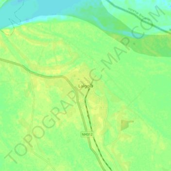
Name: Lalgola topographic map, elevation, terrain.
Location: Lalgola, Murshidabad, West Bengal, 742148, India (24.38048 88.21512 24.46048 88.29512)
Average elevation: 22 m
Minimum elevation: 12 m
Maximum elevation: 28 m
Make a donation
Gear up for your next adventure:
As an Amazon Associate, this site earns from qualifying purchases at no extra cost to you.