
Make a donation
Gear up for your next adventure:
As an Amazon Associate, this site earns from qualifying purchases at no extra cost to you.
Sirani topographic map
Click on the map to display elevation.
Make a donation
Gear up for your next adventure:
As an Amazon Associate, this site earns from qualifying purchases at no extra cost to you.
About this map
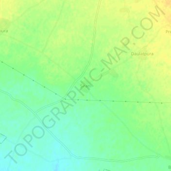
Name: Sirani topographic map, elevation, terrain.
Location: Sirani, Sanganer Tehsil, Jaipur, Rajasthan, 302037, India (26.74212 75.60795 26.78212 75.64795)
Average elevation: 352 m
Minimum elevation: 339 m
Maximum elevation: 364 m
Make a donation
Gear up for your next adventure:
As an Amazon Associate, this site earns from qualifying purchases at no extra cost to you.
Other topographic maps
Click on a map to view its topography, its elevation and its terrain.
Haldighati Park
India > Rajasthan > Sanganer Tehsil > Jaipur Municipal Corporation
Average elevation: 372 m
Ranvir shekhawat park
India > Rajasthan > Sanganer Tehsil > Jaipur Municipal Corporation
Average elevation: 413 m
Haldighati Park
India > Rajasthan > Sanganer Tehsil > Jaipur Municipal Corporation
Average elevation: 372 m