
Lwanga topographic map
Interactive map
Click on the map to display elevation.
About this map
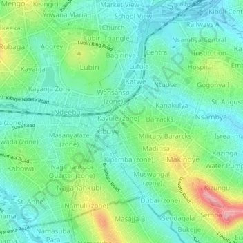
Name: Lwanga topographic map, elevation, terrain.
Location: Lwanga, Kampala, Central Region, Ouganda (0.27060 32.55353 0.31060 32.59353)
Average elevation: 1,187 m
Minimum elevation: 1,147 m
Maximum elevation: 1,286 m
Other topographic maps
Click on a map to view its topography, its elevation and its terrain.
Central
Ouganda > Central Region > Kampala
Central, Kampala, Central Region, Ouganda
Average elevation: 1,193 m
Isreal-matovu
Ouganda > Central Region > Kampala > Isreal-matovu
Isreal-matovu, Kampala, Central Region, Ouganda
Average elevation: 1,187 m