
Jubrique topographic map
Interactive map
Click on the map to display elevation.
About this map
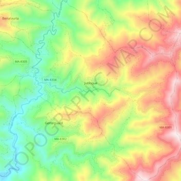
Name: Jubrique topographic map, elevation, terrain.
Average elevation: 599 m
Minimum elevation: 138 m
Maximum elevation: 1,192 m
Other topographic maps
Click on a map to view its topography, its elevation and its terrain.
Ronda
Espagne > Andalousie > Serranía de Ronda
Ronda, Serranía de Ronda, Malaga, Andalousie, Espagne
Average elevation: 801 m
Benarrabá
Espagne > Andalousie > Serranía de Ronda > Benarrabá
Benarrabá, Serranía de Ronda, Malaga, Andalousie, Espagne
Average elevation: 482 m