
Scheidegg topographic map
Interactive map
Click on the map to display elevation.
About this map
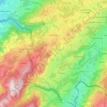
Name: Scheidegg topographic map, elevation, terrain.
Location: Scheidegg, Landkreis Lindau, Bayern, 88175, Deutschland (47.52854 9.81507 47.60993 9.88924)
Average elevation: 748 m
Minimum elevation: 478 m
Maximum elevation: 1,070 m
Naturräumlich liegt die Gemeinde am Hang eines Bergrückens, der aus gefalteter Süßwassermolasse aufgebaut ist und sich vom Pfänder oberhalb von Bregenz bis über Lindenberg hinaus von Westsüdwest nach Ostnordost zieht. Das Gemeindegebiet befindet sich in einem Höhenbereich von 600 bis 1000 m ü. NHN.
Other topographic maps
Click on a map to view its topography, its elevation and its terrain.
Lindau (Bodensee)
Deutschland > Bayern > Landkreis Lindau
Lindau (Bodensee), Landkreis Lindau, Bayern, 88131, Deutschland
Average elevation: 448 m