
Thank you for supporting this site ❤️
Make a donation
Make a donation
Gear up for your next adventure:
As an Amazon Associate, this site earns from qualifying purchases at no extra cost to you.
Mezalocha topographic map
Click on the map to display elevation.
Thank you for supporting this site ❤️
Make a donation
Make a donation
Gear up for your next adventure:
As an Amazon Associate, this site earns from qualifying purchases at no extra cost to you.
About this map
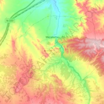
Name: Mezalocha topographic map, elevation, terrain.
Location: Mezalocha, Campo de Cariñena, Zaragoza, Aragon, 50152, Spain (41.37395 -1.13408 41.44817 -0.99369)
Average elevation: 561 m
Minimum elevation: 419 m
Maximum elevation: 710 m
Thank you for supporting this site ❤️
Make a donation
Make a donation
Gear up for your next adventure:
As an Amazon Associate, this site earns from qualifying purchases at no extra cost to you.
Other topographic maps
Click on a map to view its topography, its elevation and its terrain.
"El Cerro la Silla" (Cima oeste)
Spain > Aragon > Campo de Cariñena > Cosuenda
Average elevation: 954 m
"El Cerro la Silla" (Cima oeste)
Spain > Aragon > Campo de Cariñena > Cosuenda
Average elevation: 954 m