
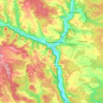
Schmidmühlen topographic map
Interactive map
Click on the map to display elevation.
About this map
Name: Schmidmühlen topographic map, elevation, terrain.
Average elevation: 431 m
Minimum elevation: 347 m
Maximum elevation: 518 m
Other topographic maps
Click on a map to view its topography, its elevation and its terrain.
Schnaittenbach
Germany > Bavaria > Landkreis Amberg-Sulzbach
Schnaittenbach, Landkreis Amberg-Sulzbach, Bavaria, 92253, Germany
Average elevation: 480 m
Pursruck
Germany > Bavaria > Landkreis Amberg-Sulzbach
Pursruck, Freudenberg, Landkreis Amberg-Sulzbach, Bavaria, 92272, Germany
Average elevation: 496 m
Schmelzmühle
Germany > Bavaria > Landkreis Amberg-Sulzbach > Freihung
Schmelzmühle, Freihung, Landkreis Amberg-Sulzbach, Bavaria, 92271, Germany
Average elevation: 427 m
Bergstein
Germany > Bavaria > Landkreis Amberg-Sulzbach > Illschwang
Bergstein, Illschwang, Illschwang (VGem), Landkreis Amberg-Sulzbach, Bavaria, 92278, Germany
Average elevation: 548 m
Vilseck
Germany > Bavaria > Landkreis Amberg-Sulzbach
Vilseck, Landkreis Amberg-Sulzbach, Bavaria, 92249, Germany
Average elevation: 443 m