
Thank you for supporting this site ❤️
Make a donation
Make a donation
Gear up for your next adventure:
As an Amazon Associate, this site earns from qualifying purchases at no extra cost to you.
Basse-Rafhay topographic map
Click on the map to display elevation.
Thank you for supporting this site ❤️
Make a donation
Make a donation
Gear up for your next adventure:
As an Amazon Associate, this site earns from qualifying purchases at no extra cost to you.
About this map
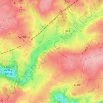
Name: Basse-Rafhay topographic map, elevation, terrain.
Location: Basse-Rafhay, Ayeneux, Soumagne, Liège, Wallonie, 4630, Belgique (50.58307 5.71215 50.62307 5.75215)
Average elevation: 224 m
Minimum elevation: 136 m
Maximum elevation: 278 m
Thank you for supporting this site ❤️
Make a donation
Make a donation
Gear up for your next adventure:
As an Amazon Associate, this site earns from qualifying purchases at no extra cost to you.
Other topographic maps
Click on a map to view its topography, its elevation and its terrain.
Domaine provincial de Wégimont
Belgique > Liège > Liège > Soumagne > Ayeneux > Basse-Rafhay
Average elevation: 226 m