
Welsberg-Taisten - Monguelfo-Tesido topographic map
Interactive map
Click on the map to display elevation.
About this map
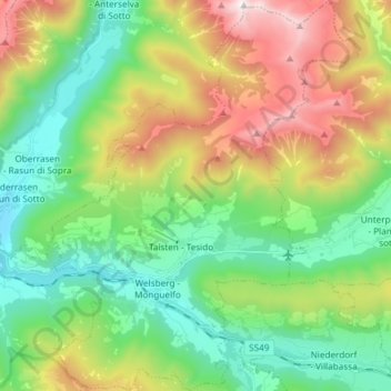
Name: Welsberg-Taisten - Monguelfo-Tesido topographic map, elevation, terrain.
Average elevation: 1,569 m
Minimum elevation: 1,009 m
Maximum elevation: 2,655 m
Other topographic maps
Click on a map to view its topography, its elevation and its terrain.
Million - Col Million
Italy > Trentino-Alto Adige/Südtirol > South Tyrol > Welsberg-Taisten - Monguelfo-Tesido
Million - Col Million, Welsberg-Taisten - Monguelfo-Tesido, Pustertal - Val Pusteria, South Tyrol, Trentino-Alto Adige/Südtirol, Italy
Average elevation: 2,239 m