Geolocate

Hodson topographic map

Click on the map to display elevation.

About this map

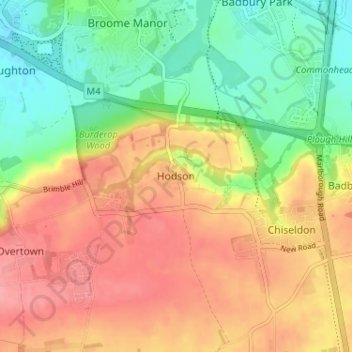
Name: Hodson topographic map, elevation, terrain.

Location: Hodson, Swindon, England, SN4 0QG, United Kingdom (51.50249 -1.77089 51.54249 -1.73089)

Average elevation: 148 m

Minimum elevation: 102 m

Maximum elevation: 192 m

Swindon trails, hiking, mountain biking, running and outdoor activities

Other topographic maps

Click on a map to view its topography, its elevation and its terrain.

Highworth

United Kingdom > England > Swindon

Average elevation: 97 m

Inglesham

United Kingdom > England > Swindon

Average elevation: 77 m

Shaftsbury Lakes

United Kingdom > England > Swindon

Average elevation: 108 m

Hannington

United Kingdom > England > Swindon

Average elevation: 88 m

Blunsdon

United Kingdom > England > Swindon > Broad Blunsdon

Average elevation: 110 m

Wroughton

United Kingdom > England > Swindon

Average elevation: 153 m

South Marston

United Kingdom > England > Swindon

Average elevation: 101 m

Wanborough

United Kingdom > England > Swindon

Average elevation: 139 m

Chiseldon

United Kingdom > England > Swindon

Average elevation: 171 m

Liddington

United Kingdom > England > Swindon > Liddington

Average elevation: 172 m

Haydon Wick

United Kingdom > England > Swindon

Average elevation: 104 m

Wroughton

United Kingdom > England > Swindon

Average elevation: 153 m

Wroughton

United Kingdom > England > Swindon

Average elevation: 153 m

Gear up for your next adventure:

🧢Waterproof Hiking Hats - Keep the rain off your face while studying topographic maps
🔦Keychain LED Torches - Emergency backup light for finding gear in your pack
🥄Titanium Camping Sporks - The ultimate lightweight utensil for trail meals
🖼️Topographic Map Art - Decorative 3D-effect posters of famous UK peaks and regions
🧼Camping Hygiene Kits - Compact hygiene essentials for outdoor stays

As an Amazon Associate, this site earns from qualifying purchases at no extra cost to you.