Geolocate

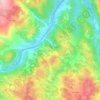
Aldeia da Ribeira topographic map

Click on the map to display elevation.

About this map

Name: Aldeia da Ribeira topographic map, elevation, terrain.

Location: Aldeia da Ribeira, Aldeia da Ribeira, Vilar Maior e Badamalos, Sabugal, Guarda, Portugal (40.43435 -6.94413 40.49152 -6.83317)

Average elevation: 816 m

Minimum elevation: 737 m

Maximum elevation: 885 m

Other topographic maps

Click on a map to view its topography, its elevation and its terrain.
Gear up for your next adventure:

📕Outdoor Navigation Books - Learn traditional and modern navigation techniques
👟Women's Trail Running Shoes - Agile footwear for fell running and technical trails
🌦️Portable Weather Meters - Handheld tools for monitoring weather conditions
🧴Tick Removal Tools - Small, essential health tool for UK woodland and moorland
📦Dry Bags - Waterproof bags to protect gear from rain

As an Amazon Associate, this site earns from qualifying purchases at no extra cost to you.