Geolocate

Mirik topographic map

Click on the map to display elevation.

Mirik

Mirik has an average elevation of 1,495 m (4,905 ft). The highest point is the Boker Monastery at about 1,768 m (5,801 ft). Mirik lake at about 1,494 m (4,902 ft) is the lowest point. Mirik is 52 km (32 mi) northwest of Siliguri city and 49 km (30 mi) south-southwest of Darjeeling town. Mirik subdivision. The name Mirik comes from the Lepcha words Mir-Yok meaning "place burnt by fire".

About this map

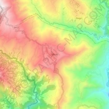
Name: Mirik topographic map, elevation, terrain.

Location: Mirik, Mirik Subdivision, Darjeeling district, West Bengal, 734214, India (26.84819 88.14884 26.92819 88.22884)

Average elevation: 1,156 m

Minimum elevation: 401 m

Maximum elevation: 1,949 m

Gear up for your next adventure:

🧤Thermal Touchscreen Gloves - Stay warm while operating your GPS or smartphone camera
Camping Shelters - Emergency and lightweight shelters for outdoor use
🎒Hiking Daypacks (20L) - Compact backpacks for day trips and technical mountain ascents
🧤Hiking Gloves - Warm and durable gloves for cold-weather walks
🧼Biodegradable Soap - Leave-no-trace hygiene for multi-day mountain treks

As an Amazon Associate, this site earns from qualifying purchases at no extra cost to you.