
Erstfeld topographic map
Interactive map
Click on the map to display elevation.
About this map
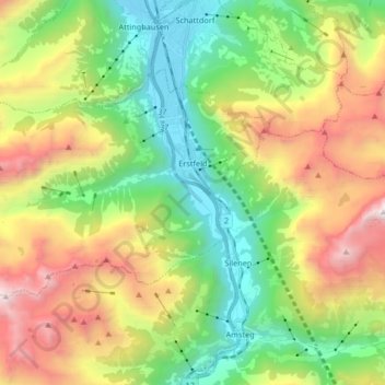
Name: Erstfeld topographic map, elevation, terrain.
Location: Erstfeld, Uri, 6472, Schweiz (46.77637 8.51750 46.84932 8.68302)
Average elevation: 1,476 m
Minimum elevation: 444 m
Maximum elevation: 3,173 m
Unter Geologen weltbekannt ist das Scheidnössli am nördlichen Dorfausgang. Hier trifft man vierzehn verschiedene Gesteinsschichten innerhalb von fünf Metern Höhe an.