Geolocate

Livadia topographic map

Click on the map to display elevation.

About this map

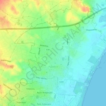
Name: Livadia topographic map, elevation, terrain.

Location: Livadia, Δήμος Λάρνακας, Larnaca District, Cyprus (34.93400 33.61016 34.97437 33.65379)

Average elevation: 18 m

Minimum elevation: -1 m

Maximum elevation: 51 m

Other topographic maps

Click on a map to view its topography, its elevation and its terrain.

Gear up for your next adventure:

🔪Outdoor Multi-Tools - Versatile tools for gear repairs and food prep in the wild
🥾Walking Shoes - Lightweight walking shoes for countryside and coastal paths
🪢Paracord - Multi-purpose cord for camping and survival
🧭Orienteering Compasses - Accurate compasses for map-based navigation
🧭Emergency Beacons - Safety beacons for remote outdoor locations

As an Amazon Associate, this site earns from qualifying purchases at no extra cost to you.