
Make a donation
Gear up for your next adventure:
As an Amazon Associate, this site earns from qualifying purchases at no extra cost to you.
Calverton CP topographic map
Click on the map to display elevation.
Make a donation
Gear up for your next adventure:
As an Amazon Associate, this site earns from qualifying purchases at no extra cost to you.
About this map
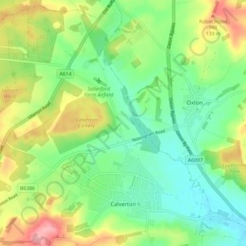
Name: Calverton CP topographic map, elevation, terrain.
Average elevation: 80 m
Minimum elevation: 33 m
Maximum elevation: 163 m
Nottinghamshire trails, hiking, mountain biking, running and outdoor activities
Make a donation
Gear up for your next adventure:
As an Amazon Associate, this site earns from qualifying purchases at no extra cost to you.
Other topographic maps
Click on a map to view its topography, its elevation and its terrain.
Arnold
United Kingdom > England > Nottinghamshire > Gedling
The local topography suggests that Arnold can never have been a haunt of eagles, because they inhabit areas of rocky outcrops, which have formed cliffs: the nearest such location is Creswell Crags, some 20 miles (32 km) north-west as the eagle flies. However, the fish-eating white-tailed eagle (also known as…
Average elevation: 81 m
Gedling Country Park
United Kingdom > England > Nottinghamshire > Gedling > Carlton
Average elevation: 80 m
Make a donation
Gear up for your next adventure:
As an Amazon Associate, this site earns from qualifying purchases at no extra cost to you.
Lambley Lane Recreation Ground (North)
United Kingdom > England > Nottinghamshire > Gedling > Carlton
Average elevation: 73 m
Colwick Country Park
United Kingdom > England > Nottinghamshire > Gedling > Carlton > Colwick
Average elevation: 32 m