
Wheathampstead topographic map
Click on the map to display elevation.
About this map
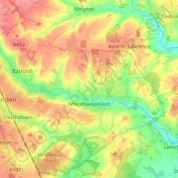
Name: Wheathampstead topographic map, elevation, terrain.
Average elevation: 109 m
Minimum elevation: 69 m
Maximum elevation: 147 m
Hertfordshire trails, hiking, mountain biking, running and outdoor activities
Other topographic maps
Click on a map to view its topography, its elevation and its terrain.
St Albans
United Kingdom > England > Hertfordshire > St Albans
St Albans was an ancient borough created following the dissolution of the monastery in 1539. It consisted of the ancient parish of St Albans (also known as the Abbey parish) and parts of St Michael and St Peter. The municipal corporation was reformed by the Municipal Corporations Act 1835 and the boundary was…
Average elevation: 100 m
Highfield Park
United Kingdom > England > Hertfordshire > St Albans > Colney Heath
Average elevation: 87 m
Blackmore End
United Kingdom > England > Hertfordshire > St Albans > Wheathampstead
Average elevation: 114 m
Lower Gustard Wood
United Kingdom > England > Hertfordshire > St Albans > Wheathampstead
Average elevation: 112 m
Tyttenhanger
United Kingdom > England > Hertfordshire > St Albans > Colney Heath
Average elevation: 83 m
Napsbury Park
United Kingdom > England > Hertfordshire > St Albans > London Colney
Average elevation: 78 m