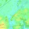
Großenwiehe topographic map
Click on the map to display elevation.
Großenwiehe
Die Höhenschichtung neigt sich leicht von Ost nach West in Richtung Nordsee. Sie fällt von durchschnittlich 28 m üNN im Osten bis auf etwa 20 m üNN im Westen. Der tiefste Punkt befindet sich in der Osterbek-Niederung mit 14,8 m üNN, während der Wieheberg mit 39,5 m üNN den höchsten Punkt bildet. Vertiefungen des Geländes sind durch die in der letzten Eiszeit als Schmelzwasserabflüsse gebildete Bachläufe von Rodau, Wiehbek, Rollau, Osterbek und Linnau mit ihren Seitenarmen entstanden.
About this map

Name: Großenwiehe topographic map, elevation, terrain.
Average elevation: 22 m
Minimum elevation: 9 m
Maximum elevation: 39 m
Other topographic maps
Click on a map to view its topography, its elevation and its terrain.

Glücksburg (Ostsee)
Deutschland > Schleswig-Holstein > Kreis Schleswig-Flensburg > Glücksburg (Ostsee)
Average elevation: 17 m

Steinberghaff
Deutschland > Schleswig-Holstein > Kreis Schleswig-Flensburg > Steinbergholz
Average elevation: 4 m


Faulück
Deutschland > Schleswig-Holstein > Kreis Schleswig-Flensburg > Rabenkirchen-Faulück
Average elevation: 27 m

Terkelstoft
Deutschland > Schleswig-Holstein > Kreis Schleswig-Flensburg > Streichmühle
Average elevation: 29 m

Unewattfeld
Deutschland > Schleswig-Holstein > Kreis Schleswig-Flensburg > Unewatt
Average elevation: 27 m


Steinberggaard
Deutschland > Schleswig-Holstein > Kreis Schleswig-Flensburg > Steinberg
Average elevation: 15 m


Sandbek
Deutschland > Schleswig-Holstein > Kreis Schleswig-Flensburg > Kappeln
Average elevation: 21 m

Rückeberg
Deutschland > Schleswig-Holstein > Kreis Schleswig-Flensburg > Kappeln
Average elevation: 12 m


Sterupgaard
Deutschland > Schleswig-Holstein > Kreis Schleswig-Flensburg > Sterup
Average elevation: 45 m


Helligbek
Deutschland > Schleswig-Holstein > Kreis Schleswig-Flensburg > Stolk
Average elevation: 25 m
Uelsbyholz
Deutschland > Schleswig-Holstein > Kreis Schleswig-Flensburg > Uelsby
Average elevation: 44 m


Barderup-Ost
Deutschland > Schleswig-Holstein > Kreis Schleswig-Flensburg > Barderup
Average elevation: 32 m


Haveholz
Deutschland > Schleswig-Holstein > Kreis Schleswig-Flensburg > Brunsholm
Average elevation: 48 m


Lüttfeld
Deutschland > Schleswig-Holstein > Kreis Schleswig-Flensburg > Kappeln
Average elevation: 12 m


Langfeld
Deutschland > Schleswig-Holstein > Kreis Schleswig-Flensburg > Kronsgaard
Average elevation: 5 m


Schausende
Deutschland > Schleswig-Holstein > Kreis Schleswig-Flensburg > Glücksburg (Ostsee)
Average elevation: 3 m


Sörupmühle
Deutschland > Schleswig-Holstein > Kreis Schleswig-Flensburg > Flatzby
Average elevation: 44 m
Brarupholz
Deutschland > Schleswig-Holstein > Kreis Schleswig-Flensburg > Scheggerott
Average elevation: 42 m
Ulsnisland
Deutschland > Schleswig-Holstein > Kreis Schleswig-Flensburg > Ulsnis
Average elevation: 13 m
Alt Hasselberg
Deutschland > Schleswig-Holstein > Kreis Schleswig-Flensburg > Hasselberg
Average elevation: 3 m
Tolkschuby
Deutschland > Schleswig-Holstein > Kreis Schleswig-Flensburg > Tolk
Average elevation: 23 m
Rabenkirchen
Deutschland > Schleswig-Holstein > Kreis Schleswig-Flensburg > Rabenkirchen-Faulück
Average elevation: 31 m
Ulegraff
Deutschland > Schleswig-Holstein > Kreis Schleswig-Flensburg > Brunsholm
Average elevation: 43 m
Gammelbyholz
Deutschland > Schleswig-Holstein > Kreis Schleswig-Flensburg > Sörup
Average elevation: 38 m

Altholzkrug
Deutschland > Schleswig-Holstein > Kreis Schleswig-Flensburg > Handewitt
Average elevation: 40 m


Süderbraruproy
Deutschland > Schleswig-Holstein > Kreis Schleswig-Flensburg > Süderbrarup > Dollrottfeld
Average elevation: 25 m

Gintoftholz
Deutschland > Schleswig-Holstein > Kreis Schleswig-Flensburg > Norgaardholz
Average elevation: 4 m

Lippingau
Deutschland > Schleswig-Holstein > Kreis Schleswig-Flensburg > Niesgrau > Schnogholm
Average elevation: 7 m

Großsteingrab Philippstal
Deutschland > Schleswig-Holstein > Kreis Schleswig-Flensburg > Gintoftholm
Average elevation: 14 m

Bojum
Deutschland > Schleswig-Holstein > Kreis Schleswig-Flensburg > Wippendorf
Average elevation: 32 m

Klueshof
Deutschland > Schleswig-Holstein > Kreis Schleswig-Flensburg > Harrislee > Niehuus
Average elevation: 33 m

Knös
Deutschland > Schleswig-Holstein > Kreis Schleswig-Flensburg > Brodersby-Goltoft
Average elevation: 11 m


Kobbellück
Deutschland > Schleswig-Holstein > Kreis Schleswig-Flensburg > Glücksburg (Ostsee) > Bockholm
Average elevation: 6 m

Osterholz
Deutschland > Schleswig-Holstein > Kreis Schleswig-Flensburg > Westerholz
Average elevation: 13 m

Lüttfeld
Deutschland > Schleswig-Holstein > Kreis Schleswig-Flensburg > Kappeln
Average elevation: 12 m
Schnarup
Deutschland > Schleswig-Holstein > Kreis Schleswig-Flensburg > Schnarup-Thumby
Average elevation: 31 m