Geolocate

Stillwater topographic map

Click on the map to display elevation.

About this map

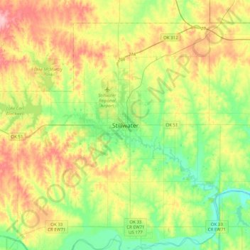
Name: Stillwater topographic map, elevation, terrain.

Location: Stillwater, Payne County, Oklahoma, 74077, United States (35.95563 -97.21857 36.27563 -96.89857)

Average elevation: 295 m

Minimum elevation: 242 m

Maximum elevation: 376 m

Other topographic maps

Click on a map to view its topography, its elevation and its terrain.

Enclave

United States > Oklahoma > Payne County > Stillwater

Average elevation: 271 m

Gear up for your next adventure:

🥾Women's Waterproof Hiking Boots - High-performance trekking boots designed for all-weather comfort
Lightweight Tents - Compact tents for backpacking and trekking
🥼Base Layers - Thermal base layers for temperature regulation
🧥Packable Down Jackets - Lightweight warmth that compresses small in your bag
🎒Multi-day Trekking Packs - Large capacity backpacks for wild camping and long-distance trails

As an Amazon Associate, this site earns from qualifying purchases at no extra cost to you.