Geolocate

Dansa topographic map

Click on the map to display elevation.

About this map

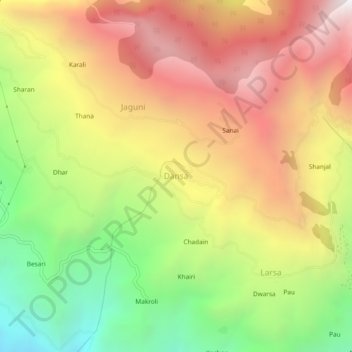
Name: Dansa topographic map, elevation, terrain.

Location: Dansa, Rampur, Shimla, Himachal Pradesh, 172022, India (31.39883 77.64934 31.43883 77.68934)

Average elevation: 2,001 m

Minimum elevation: 1,042 m

Maximum elevation: 2,915 m

Other topographic maps

Click on a map to view its topography, its elevation and its terrain.

Daranghati WLS

India > Himachal Pradesh > Rampur > Kasha

Average elevation: 3,565 m

Gear up for your next adventure:

🛌Sleeping Mats - Insulated mats for comfortable outdoor sleeping
🧤Waterproof Overmitts - Extreme weather protection for hikers and mountaineers
🪓Outdoor Multitools - Versatile tools for hiking and camping
🧷Tenacious Repair Tape - Instant fix for torn tents, jackets, or dry bags
📷Outdoor Action Cameras - Cameras designed for hiking and adventure

As an Amazon Associate, this site earns from qualifying purchases at no extra cost to you.