
Ham Hill topographic map
Interactive map
Click on the map to display elevation.
About this map
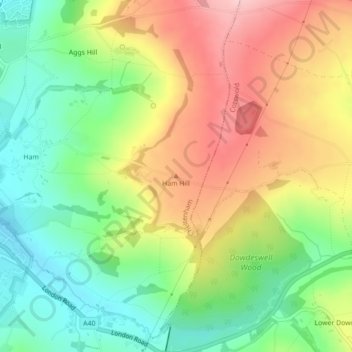
Name: Ham Hill topographic map, elevation, terrain.
Average elevation: 179 m
Minimum elevation: 87 m
Maximum elevation: 293 m
Other topographic maps
Click on a map to view its topography, its elevation and its terrain.
Pittville Park
United Kingdom > England > Cheltenham
Pittville Park, Sandford, Pittville, Cheltenham, Gloucestershire, South West England, England, United Kingdom
Average elevation: 61 m
Harp Hill
United Kingdom > England > Cheltenham > Harp Hill
Harp Hill, Charlton Kings, Cheltenham, Gloucestershire, South West England, England, GL52 6PR, United Kingdom
Average elevation: 126 m